With accelerating climate change and rising sea levels due to global warming, there has been a significant disruption in hydrological cycles globally. Heavy rainfall and flooding regularly inundates most of our cities, destroying natural and infrastructural ecosystems.
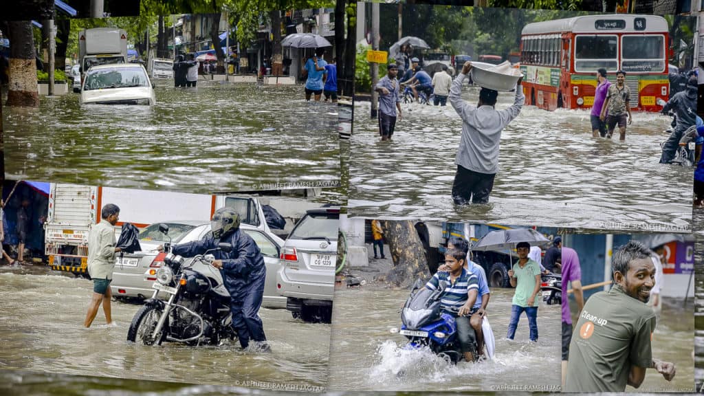
Mumbai, home to around 20 million people, is no different. The monsoon downpours bring the city to a standstill year after year. There is also the threat of cyclones and storms from the Arabian Sea such as Takutae earlier this year – those that can potentially cause havoc in the coastal city. Why is it that the city is not equipped to deal with such recurring flood-like situations?
Reasons for water logging
Historically, Mumbai comprised seven islands, which have been filled up today. There are large parts of the city, however, that still lie below the sea level and are prone to flooding. The city’s water systems were also designed for particular standards during the British rule.
According to the BMC (Brihanmumbai Municipal Corporation), our storm-water drains were designed for 40-millimetre rain within 24 hours. These standards, however, don’t apply anymore because of climate change; Takutae, for instance, brought 230-millimetre of rain in a single day. The amount and pattern of rainfall that Mumbai will have to deal with as the years go by will obviously be even more erratic and of a higher order.
Read more: The case against Mumbai’s Coastal Road project
To add to this, rampant construction in the city has reduced its water absorption capacity. The destruction of mangroves that previously absorbed excess water is a major cause of flooding.
Water is unable to percolate into the soil through paved surfaces and collects on roads and plazas instead. New-age infrastructure projects including the coastal road project are also, in a sense, part of the problem as they highlight how we’ve been building inappropriately.
Such developments ignore the eco-sensitive nature of the inter-tidal zone. Reclamation (which is a funny word because this land was never ours in the first place) from the sea and land-filling doesn’t just desecrate fragile coastal ecosystems, it creates a dam between the city and the sea, affecting natural storm-water drainage patterns and increasing the threat of flooding manifold.
No action taken to reduce flooding
Flood-prone areas were mapped extensively after the 2005 floods by the Madhavrao Chitale Committee, in 2006, recommended that certain areas were not be constructed upon. The committee also gave suggestions on what kind of pump systems should be used to regulate the flow of water.
There are, in fact, numerous works and extensive reports that indicate that the knowledge to deal with flooding exists, but the Development Plan 2034 has turned a blind eye to this, including the recommendations of the Madhavrao Chitale Committee.
What should be our action plan? First, and most importantly, we need to stop construction in low-lying areas. As thresholds between land and water, these zones are more prone to waterlogging with extremely sensitive ecosystems and must not be built upon.
We must also work towards both reviving and upgrading our stormwater systems and allow for improved percolation. To that end, we need to increase the capacity of the drainage systems to meet new standards that are relevant today. It is also essential to design surfaces that allow for percolation, and steer away from concretizing asphalt on streets as it slows down the path of water. Natural drainage systems too can go a long way in regulating the flow of water – creating holding ponds, either underground or on ground, preserving mangroves that act as natural holding ponds themselves, and promoting softscaping.
Finally, there is a critical need to plan and implement long-term policies and amend old ones — to regulate construction, and successfully address the impact of increasing extreme weather events in the city. In India, the Coastal Regulation Zone (CRZ) rules govern human and commercial/industrial activity close to the coastline in order to protect the fragile ecosystems near the sea. Such regulations and developmental plans should be strictly enforced to safeguard our coastal cities against the unforeseen eventualities of climate change.
One more important reason is absence of maintenance of storm water drains, nallahs, marine outfalls and pumping stations throughout the year. Hundreds of crores are spent on useless and token de-silting couple of weeks before monsoon.
Sadly none in the government or BMC bothers as they face this only only few days in a year!