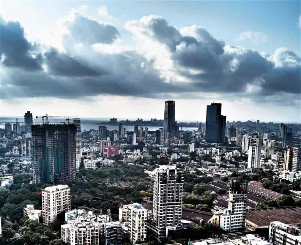
Both the Western and Eastern coastlines of Mumbai are in for a sea change. While a Rs 14,000 crore Coastal Road Project is being implemented on the Western coastline, different groups are proposing vastly varied ideas for the 21-km Eastern side that stretches from the Bombay Dockyard to Wadala.
What Mumbai Port Trust wants to do
The Mumbai Port Trust (MbPT), which oversees the planning for the Eastern Waterfront project has decided to commercially develop 25.63% of land, another 23.26% will be used for ecotourism and 10.76 % to rehouse local slum-dwellers. By ecotourism they mean cruises, a marina, promenades, while also hoping to upgrade infrastructure on the landward side.
MbPT intends to build a waterfront transit corridor for inter-city and intra-city connectivity and integrate the same with other transport corridors of the city like rails, road, mono rail and metro networks. Once they do this, the Eastern Waterfront will be one of the city’s most well connected stretches of land.
The plan included providing a ‘Roll On Roll Off’ water transport for passengers and small vehicles. This Ro-Ro service, as it is known, was flagged off on March 15, 2020 between Mumbai’s coast at Bhaucha Dhakka to Mandwa in Alibaugh reducing the drive time between these two destinations from four hours to one. The service has a vehicular carrying capacity of 1000 people and 200 cars in good weather conditions.
An architect’s vision
Bimal Patel, the architect who designed the Sabarmati Waterfront in Ahemdabad and is now re-designing the Indian Parliament, unveiled his plans in February 2020 to commercially develop 625 acres on Mumbai’s eastern coast. His plan includes keeping just 7 km of promenade open for the public as against 21 kms suggested by an earlier ex-MbPT chairperson led Rani Jadhav committee report.
The Rani Jadhav committee report was never made public but activists got it through the Right to Information Act.
What this means for Mumbai is that 625 acres of prime land running parallel to areas from Nariman Point to Sewri in Central Mumbai, will be open for commercial development.
Activists say concretising the Eastern Waterfront will add to the chaos in the city. “This area was supposed to serve as a green lung for the city,” said Zoru Bhathena, a Mumbai-based activist. “This is nothing but a cock-eyed proposal at the tax payer’s expense. They are planning huge skyscrapers without giving much thought to the how they will cater to the corresponding hike in demand for support infrastructure in terms of water, energy, sewage, drainage etc. Prime commercial areas like Nariman Point and Cuffe Parade are witnessing empty flats;” he says.
Ecological viewpoint
In its Citizens Vision statement released in 2014, A PortLands Initiative (APLI) Mumbai, an advocacy group that focuses on regeneration of Portlands, is pushing for multi pronged development including a flamingo bird sanctuary and mangrove park at Sewri, developing a water sports center to include sports like sailing, rowing, kayaking, water skiing and even water scooters, encouraging tourism by showcasing Mumbai’s Koli seafood cuisine; developing fish processing industry at Sassoon Dock, developing a seafarers vocational training institute, a museum of maritime history and trade, a marina for yachts and sailing boats, even setting up of a Port Lands University along with stadia for various sports. “These are the last remaining spaces that Mumbaikars can lay a claim to, to create a more liveable city,” says I.C. Rao of APLI , Mumbai.
The Sewri Eco-park project already includes the development of flamingo and mangrove parks, it is currently awaiting clearances from the Union Environment. The Eco-park development plan also includes developing the 1680-built heritage Sewri Fort that lies in a dilapidated condition. due to lack of proper access and basic facilities for visitors there.
Houses for the needy?
Many urban planners feel that the space could be used to create affordable housing as Mumbai is one of the most crowded metropolises. It offers 1 sq.m per capita open space and its per capita built up area is just 9 sq.m as against the 25 sq.m suggested by the National Habitat Policy.
“Mumbai currently faces major deficiencies in amenities for housing, health, education,” says Pankaj Joshi, executive director of the Urban Design and Research Institute (UDRI), a non-profit that focusses on urban design and planning. He believes the Eastern Waterfront could go a long way in meeting those goals.
The city is linear. Since the South end is cramped with commercial complexes which are serviced by those residing at far North end, the public transport systems and the Express Highways are over-burdened.
However, APLI Mumbai’s Rao is opposed to it. “If affordable housing is allowed, then it will open the doors to develop all kinds of housing including luxury towers. Redeveloped houses should be provided only for those already living in the informal housing in the Portlands,” he says.
And perhaps he has a point. In the recent past, close to 1000 acres of land in the Bandra Kurla Complex (BKC) and 600 acres of Cotton Mill land in Central Mumbai were open for development. Both times, activists advocated to either use the space to create green tracts or for housing the poor. But, both were used to build expensive offices and houses.
At Lower Parel, mill land has been replaced with tall skyscrapers.But lack of wide roads or railway stations, create traffic jams. Flouting building norms killed 14 people in rooftop pubs in December 2017 in Kamala Mill Compound. In September that year, 23 people died in a stampede caused due to overcrowding on the Prabhadevi station foot over bridge.
While Bandra Kurla Complex is lined with wide roads and footpaths, its two big open green spaces are taken over by the influential MIG Cricket Club and the Jio gardens. The development of BKC as a Central Business District also failed to shift traffic and congestion from the Southern end of the city to the suburbs.
Behind the scenes
Historically key centers for economic growth were developed on public land. For example, Nariman Point, the Bandra Kurla Complez, mill land in Lower Parel etc all contributed to the development of south Mumbai as it stands now. But space is a constraint in an over populated city like Mumbai.
Since the Western waterfront has been entirely taken up for building a single road, there is only the eastern side that can be used to create green spaces and affordable housing instead of ecotourism and commercial buildings.
“These glossy assertions and global ambitions for the waterfront is after all a cover for what it really is: a real-estate megaproject with the aim of converting power into property. The city is being asked to forego all of its waterfront land for 6.4% open space,” writes Hussain Indorewala, a Mumbai-based activist and professor of architecture. “The air rights (unused built potential of open plots) of all the gardens and roads of this 253-hectare site will be amassed on the commercial plots. The result? A “Hi-Tech City” on the waterfront, affirming yet again Mumbai’s variation on Murphy’s Law: if real estate can go higher, it will.”
The article by Hepzi Anthony has brought out diverse views which should all be accommodated by MbPT now designated as the Special Planning Authority under the MRTP Act. We need to see pre-emptive action to create parks at Sewree and Hay Bunder with minimal expenditure and a user friendly marina in the tenure of the new Chairman whom we welcomed on 1 Aug